Cycling is one of life’s great joys, especially because it’s free to do and offers cyclists who do it often a wide-range of health benefits. However, getting from A to B hasn’t always been the easiest part of it all, forcing those on the move to stop to consult a map or a smartphone for directions, ultimately ruining the fun.
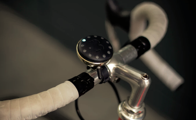
Blubel is a satellite navigation system built within a bike bell. Riders input their destination into Blubel’s companion iOS/Android app and leads riders to their destination using a set of LEDs. On the way, a set of lights indicates a right turn and another indicates a left turn, both of which are prefaced by an audible ping to indicate one is coming up. When close to a destination, a steady LED lights up and acts as a compass. What sets Bluebel apart, though, is its crowdsourced mapping.
Every time a Blubel is rung, it indicates an alert point in the supporting app and cloud technology, data which is analyzed to calculate the safest route and highlight potential hazards for others. In combination with its distance, time, and calorie tracker along with bike locator, Bluebel is a simple way to get places without having to worry about dangerously glancing at a smartphone or stopping altogether. $70 gets riders a silver-toned Bluebel, with other colors available at different prices. It is slated to ship in December 2016 should the Kickstarter campaign raise $40,000 by July 21st, 2016.
Blubel follows a long line of similar, turn-by-turn biking devices built with cyclists in mind. But while the SpeedForce, SmartHalo, and TrekAce all use a combination of lights, sounds, and vibrations to get you home, only the BluBel takes it a step further with its crowdsourcing navigational capabilities. This single addition transforms the platform into something more useful and safer than a simple navigation device.